In Praise of the Illustrative Map
Maps are more than tools for getting around. They can be works of art, storytellers, and windows into the heart of a place. While Google Maps and GPS-enabled smartphones have made getting from point A to point B easier than ever, something has been lost: the joy of discovery, the connection to place. We may no longer need large paper maps to find our way, but we crave something more: maps that resonate with our love for a place.
Enter illustrative maps—vibrant, imaginative representations of places that transcend the ordinary, offering a unique and engaging perspective. They’re artistic expressions that tell stories, capture the essence of a place, and engage viewers in ways traditional maps cannot.
At All Together, we believe design is more than aesthetics; it's about forging connections and weaving meaningful narratives. Illustrative maps exemplify this perfectly, seamlessly blending art and functionality to bring a community's spirit, personality, history, and aspirations to life. These maps breathe life into spaces, fostering a deeper connection while infusing a touch of fun and whimsy.
In this post, we’ll dive into the power of illustrative maps in branding and community engagement, showcasing our work at All Together and demonstrating how these maps can help tell the unique stories of your community.
What Are Illustrative Maps?
Illustrative maps are essentially artistic representations of places. In contrast to traditional maps, which rely on accuracy and scale, illustrative maps simplify and stylize the geography to emphasize the features and spirit of a place. They allow us to tell a story, bringing in elements that reflect the cultural, historical, and emotional identity.
These maps aren’t new; they’ve been around for centuries. Perhaps this old-school, yellowed map used to charter the sea immediately comes to mind for you. Sure, the intricate font is seemingly impossible to read, but notice the embellished border. Borders or frames on pictorial maps were traditionally used to illustrate the history of a place. It’s this rich tradition of storytelling through illustration that we continue to tap into today, using modern design to make maps both functional and visually engaging.

Source: American Geographical Society Library
Whether highlighting landmarks, businesses, or historical moments, illustrative maps connect viewers with the unique character of the area. From playful icons to rich illustrations, they capture the feeling of a place in a way that engages people visually and emotionally. They’re perfect for guiding locals, tourists, or new residents, while also telling the story of an area’s past, present, and future. Whether you want to promote a new development, celebrate local businesses, or help people explore green spaces, illustrative maps make navigating and experiencing a place feel more accessible, personal, and exciting.
Why Use Illustrative Maps?
Bringing Places to Life
Illustrative maps help convey the unique personality of a space. Whether it's a historic district, a cultural neighborhood, or a new urban development, these maps capture the essence of a place. By using artistic design elements, you can highlight what makes a community or project unique, from iconic buildings to local hangouts.
Simplifying Complex Information
Depicting cities, counties, or regions can be a daunting task. Cities often have winding streets, crowded blocks, and complex intersections. Meanwhile, sprawling counties can span miles, making it difficult to capture sufficient detail on traditional maps. Illustrative maps offer a solution, simplifying these areas for easy reference. Guiding people intuitively to key destinations, they’re perfect for new developments, large events, or areas with a high concentration of features.

All Together’s map of the LaSalle Street Corridor in downtown Chicago
Building Community Connection
Maps are a powerful way to build a sense of community. When designed thoughtfully, an illustrative map can make people feel more connected to a place by showcasing local businesses, parks, trails, landmarks, and cultural hotspots. It’s a way of celebrating the community’s story and inviting others to engage with it.
Marketing and Branding
For municipalities, business districts, or tourism boards, illustrative maps are a useful place branding tool. They go beyond the typical promotional brochure by offering a visually appealing representation of your community. Whether for a new residential development or a city-wide event, illustrative maps help attract attention and make the brand feel more inviting and personal.
All Together Client Examples
We’ve had the opportunity to create a variety of illustrative maps that help communities connect with their spaces. Here are some of our favorite examples from recent projects:

All Together collaborated with the City of Evanston to launch Enjoy Evanston, a go-to source for what’s happening throughout Evanston, IL – from events to local business news, and recommendations for locals and visitors on where to dine, drink, and shop. We developed a map to highlight the different business districts and promote each area’s unique character and connection to the larger brand.

As an initiative of the Chicago Community Trust, WRT is a corporate and philanthropic funding collaborative investing in Black and Latinx communities in Chicago and Cook County, IL hit hardest by the COVID-19 pandemic. We designed a map to showcase the different anchor projects that were awarded grants.

Located in downtown Chicago, LaSalle Street is a historic corridor known for its impressive architecture and major financial institutions. All Together partnered with the City of Chicago and community members in a visioning process to shape a shared outlook for the corridor. We created a vibrant, large-scale map of LaSalle Street for a participatory mapping activity during an open house event. The map served as a canvas where participants could mark locations with color-coded pins and share their experiences and suggestions for improvements using sticky notes and prompts.

All Together partnered with Nassau County and community stakeholders to develop a shared vision for the county. We encouraged participants to journey around the county to share their feedback on community building blocks and draft growth scenarios using a themed map pamphlet at the Annual Christmas Tree Lighting event. This "passport" activity featured winter wonderland-inspired stations (Candy Cane Forest, Sea of Swirly Twirly Gumdrops, etc.) superimposed on the county's geography. Participants collected stickers at each station after providing feedback, earning a prize for visiting four or more.
As part of our broader branding work for Lemont Downtown, IL, we designed an illustrative map to provide a high-level overview of the downtown district, particularly its connection to the I&M Canal Trail and The Forge: Lemont Quarries. These maps were placed in kiosks along the I&M Canal to encourage people walking the trail to explore Lemont's dining and shopping establishments.


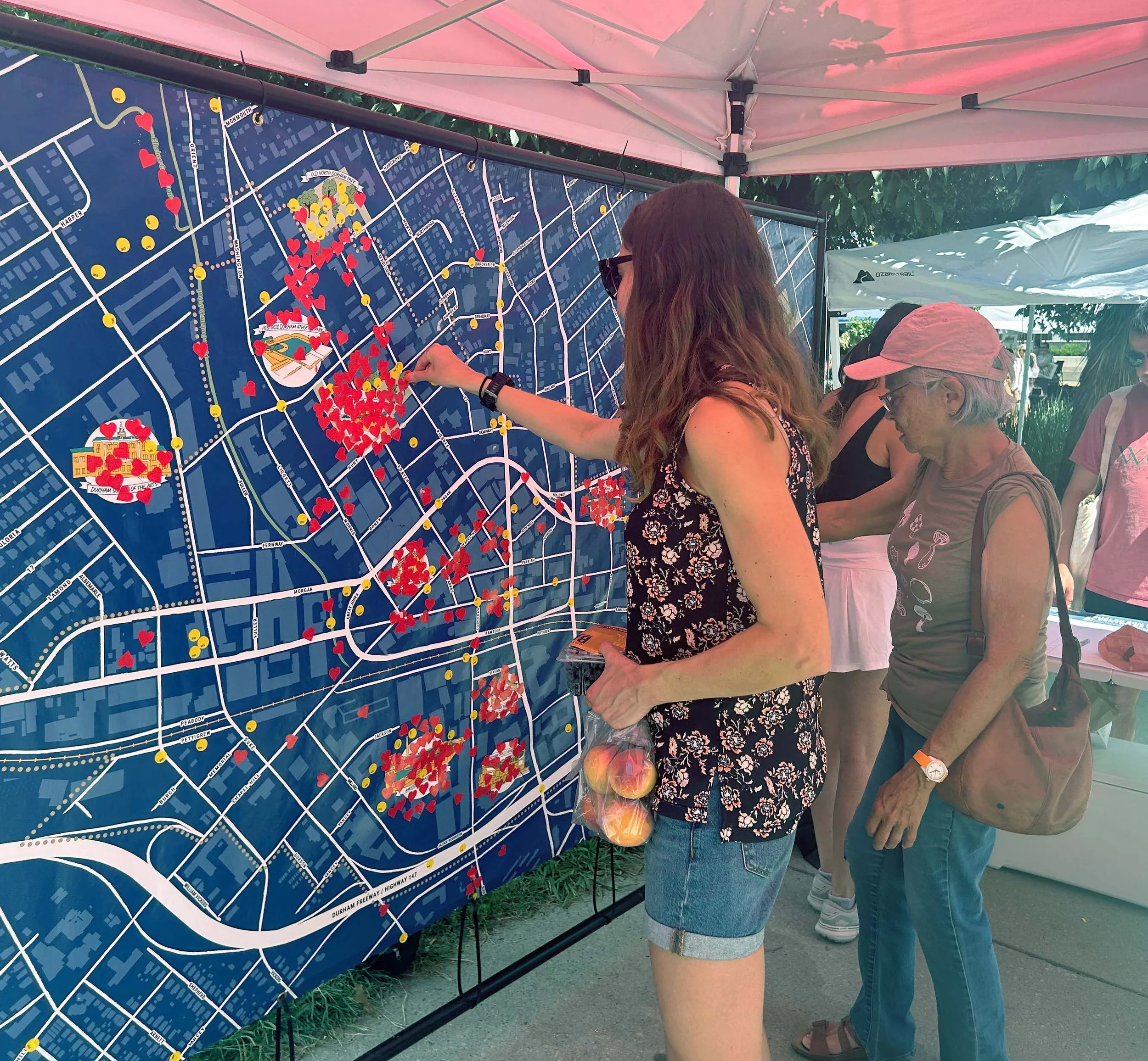
Downtown Durham Blueprint: 2035
Downtown Durham has experienced significant growth and change since its last master plan 23 years ago, prompting the launch of Downtown Durham Blueprint: 2035. This new plan, spearheaded by Downtown Durham, Inc., aims to balance preserving the area's unique character with supporting continued development. All Together, in partnership with innovative collaborators, is leading community engagement throughout the planning process. As part of this effort, we came up with an illustrated map for a participatory activity where attendees marked their favorite downtown locations and shared future visions using numbered dot stickers corresponding to written comments.

The Odawa Prosperity Project is a community-led initiative to identify economic priorities, understand the needs of the Tribal workforce, and create a prosperous pathway for the future of the Little Traverse Bay Bands of Odawa Indians Tribe (LTBB) in Michigan. For a pop-up event, All Together designed a participatory mapping activity showcasing tribally-owned land and assets. Participants used stickers representing various community amenities to indicate where they envisioned these elements occurring throughout the map.


How to Create Your Own Illustrative Map
Creating your own illustrative map can be a rewarding process. Here’s a basic outline of how we approach the design process at All Together:
Understand the Purpose
Before diving into the design, clarify your map's purpose and the area it will cover (e.g., a few blocks, a neighborhood, or an entire city). Are you highlighting key landmarks? Telling a story? Or simply helping people navigate? Your map's purpose will be the foundation of your design.Identify Sites and Activities
What are the key features of the space you’re mapping? These could be businesses, parks, historical sites, green spaces, or anything else relevant to your map's purpose. Feel free to personalize it with a theme, like "best coffee shops" or "favorite dog walking routes."Sketch Your Layout
Start with a rough sketch. Don’t worry about getting it perfect at first—focus on arranging key features in a way that’s easy to follow and visually interesting.Design and Illustrate
Once you’ve got your layout, start adding in your illustrations, including a title, roads, icons, and fun accents. Whether you’re hand-drawing elements or using digital tools, ensure the style of the illustrations reflects the tone of the space you’re mapping.Refine and Polish
After the illustrations are in place, fine-tune the map’s colors, typography, and overall flow to ensure it’s visually appealing and easy to read.Print or Share
Finally, print your map or share it digitally. Whether for a local community event, planning project, or tourism campaign, make sure it’s easy for people to access and enjoy!
The Future of Mapping
At All Together, we’re always looking for new ways to help communities connect with their spaces. As one of the best community engagement ideas, illustrative maps excel at visually engaging audiences, conveying narratives, and forging stronger bonds. Whether you’re starting a new plan, promoting local businesses, or celebrating the history of your community, an illustrative map can help you capture the essence of your area in a way that’s both functional and fun.
If you're interested in learning more about how we can bring your project to life with an illustrative map, we'd love to hear from you! Drop us a message to start the conversation.